- be meant, primarily, for adventure. [not just a method to get from point A to B. There might not even be a point B]
- provide interesting/meaningful choices (and consequences). [otherwise might as well be riding a RailRoad]
- be Terra Incognita to the characters and most NPCs. [exploration / discovering unknown is wilderness adventure's "draw"]
- be divided into regions of like geography/ecology/danger. [facilitates custom encounter tables, identifiable descriptive traits, players ability to recognize increasing danger (see next)]
- be arranged so that the farther one goes from civilization the more imperiled one's life becomes. [the basic sandbox risk/reward equation]
- somewhat limit the scope of the campaign via "impassable terrain" or other hopefully non totally obvious means. [a Mythic Wilderness is more detailed than "backdrop wilderness" and there's a need constrain area if DM is to give it the proper attention]
- be Judges Guild's Campaign Hexagon System compatible. Meaning numbered 5mi hexes arranged a certain way. [personal requirement so my JG stuff "drops in", besides it's pretty nifty]
A Breakthrough
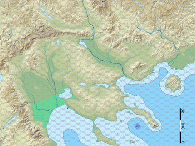
Read a blog post recently (sorry lost which one in the deluge). It noted that the map of Greece with all those islands and rugged terrain screams for adventure and begs to be explored. At the time I thought, "yeah, meh, whatever". Later when looking over my National Geographic map collection I noticed the Macedonia region on a relief map of the world. It was structurally close to what I had envisioned for GnG's map. And I began to grasp the wisdom of that blogger. After seeing the topo SVG map from that wiki page I knew I had found my cartographic grail.
It took some work to make the hex grid, and to scale the image so 1 hex = 5mi, and to make the several layers. I've also been adding swamps, raising mtns, and sinking a peninsula. Must watch myself though. Computer and detailedness makes it easy to fall into the over/endless editing trap. Must remember "broad brush strokes" and "detail it when you need it, not before" aka JIT. So far I'm happy and enjoying myself! No claims to be the best map ever. Works for me and more importantly has gotten my ass motivated to get this campaign started.
I present the Eastern Frontier. The safe, boring Kingdom lies off to the lower left. The rest is the unexplored!
I'm sort of sold (at least this week) on vector based / free hand maps and against the tyranny of the hexgrid. Which would seem to make Campaign Hexagon System compatibility a wee bit difficult. I resolve this by using hexgrid overlay on top of my nice hexfree map. Either via software "layers" or hexgrid printed on transparency. I create, draw, design without the grid, then throw the grid on for location write up / play. Hopefully getting best of both worlds. Here's the hexified version (sorry, only posted 1/4 sized images, but trust me those are numbered hexes)

A league is three miles and the distance man/horse can walk in an hour. I've decided to treat my 5mi hexes a 2 leagues or two hours of travel. Two hours seemed like a good duration for a wilderness "turn". Probably about the time travelers should rest and reorientate themselves. Also nice time to checks for encounters, getting lost, etc. A group can do 4 (5 if pushing it) turns of wilderness travel.
Reality Ain't So Bad
Since working on this I've discovered several advantages to using real word maps. First and most obvious is that you get a fairly detailed map with very little work. There's likely to be many more maps of various types depicting the area, for free online. Such as these awesome topo maps. At the very least there will be Google Map sat images and topo maps. I find it difficult to visualize terrain from a map, even topo maps. Google Earth provides a whole new perspective :). Google Earth is also great for finding photos taken of the area. These provide more visual aides, ideas for descriptions, flora, and fauna. One boon I wasn't expecting is that several times already the map had a feature that inspired me to add something to the game world I had not thought of.
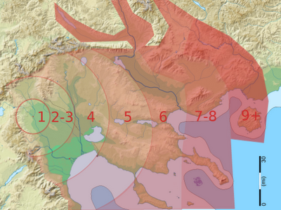
This version shows roughly the "bands" of increasing danger as you get farther away from the edge of civilization aka the "keep on the borderlands". Going further to the west (and off map) the bands would decrease until one reached the Stygian Empire. Up North is... something. It's good to keep a few mysteries.

Hexaphobia
Ars Lundi "Running your Own Western Marches" and my own tendency to be distracted by grid led to my avoidance of hexmaps. I still absolutely adore Mystara style maps. Which are the right thing for continental and world maps. At that scale you don't really care about the details cause you can't show enough of them to matter.
From Ars Lundi article:
It was a vector map, so I could zoom in or out to any scale I wanted. I printed a variety of maps at different scales if I there were interesting things to see in the area. No one needs a close-up map at one inch = one inch of a barren plain.
That author felt hexes lead to the belief/behavior of one thing per hex and once it's found players no longer interested in looking there. I can also see hexes removing the mystery and tension of exploring/getting lost, "meh, we're only 1 hex away from the road".
More from Ars Lundi:
I didn’t use hex maps, just free movement and distances. It kept things organic and made it easy to get lost / disoriented, which was good. To track movement I just got distances and bearings from the party (”we’ll march southwest for 2 miles”), checked to see if they were going the way they thought (wilderness lore) and then drew the vector on the map to see where they actually were.YMMV
Blogbliography (incomplete as usual)
- http://ww.dragonsfoot.org/forums/viewtopic.php?f=15&t=36433
- http://ode2bd.blogspot.com/2009/11/wilderness-maps.html
- http://batintheattic.blogspot.com/2009/12/packing-stuff-inside-hex.html
- http://planetalgol.blogspot.com/2009/12/how-i-handle-hexcrawling.html
- http://dndwithpornstars.blogspot.com/2009/12/hexcrawls-worldbuilding-vs-microlite-s.html
- http://grognardia.blogspot.com/2009/01/campaign-map.html
- http://redbox.wikidot.com/stepping-through-hex-scales
- http://www.philotomy.com/#dungeon
- http://www.io.com/~sjohn/demog.htm
MkHexGrid
mkhexgrid software make almost any hexgrid you want, download it. A couple spec files I used:
#gng_letter_hex
output = ps
outfile = gng_letter_hex.ps
centered = true
image-width = 11in
image-height = 8.5in
image-margin = 0.3in
hex-width = 0.375in
grid-grain = h
grid-thickness = 0.5pt
grid-start = o
grid-color = 0.8,0.8,0.8
coord-origin = ur
coord-bearing = 0
coord-tilt = -90
coord-distance = 0.1in
coord-color = 0.6,0.6,0.6
center-style = n
coord-font = Helvetica
coord-size = 6pt

#jg_hexagon
output = ps
outfile = jg_hexagon.ps
centered = true
image-width = 11in
image-height = 8.5in
image-margin = 0.3in,0.3in,2in,0.3in
hex-width = 0.3in
grid-grain = h
grid-thickness = 0.5pt
grid-start = o
grid-color = 0.8,0.8,0.8
coord-origin = ur
coord-bearing = 0
coord-tilt = -90
coord-distance = 0.08in
coord-color = 0.6,0.6,0.6
center-style = n
coord-font = Helvetica
coord-size = 6pt


The map of Greece was me. Glad it got your creative juices flowing!
ReplyDelete@David awesome and thanks you were totally right.
ReplyDeleteI don't know much about this game, but to me looks like some kind of D&D mini quest, maybe a controlled quest to play in a couple of hours or days, I always want to play one D&D quest that only cab played for one night no more no less.
ReplyDeleteGeneric Viagra Buy Viagra