Showing posts with label maps. Show all posts

Wednesday, January 21, 2015

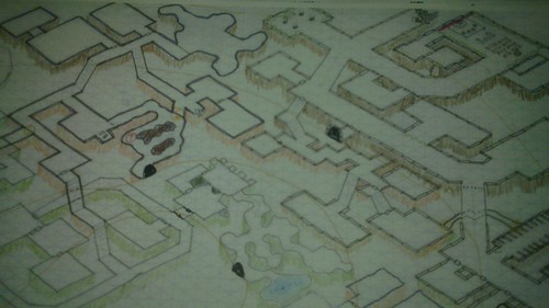
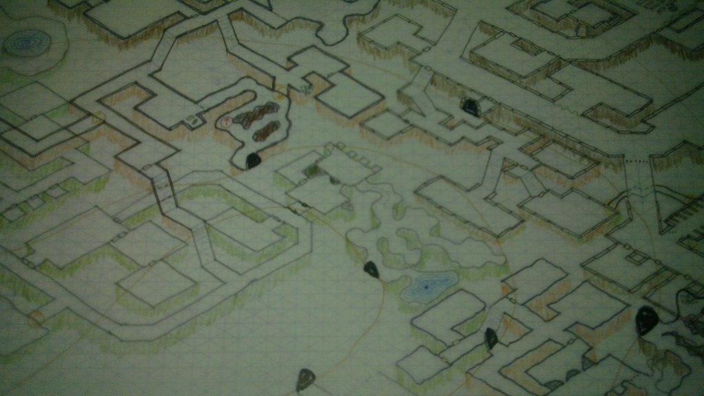
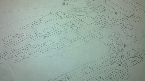
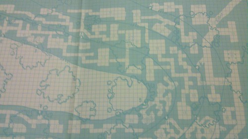
Pleskos Map

Yes it is a map of Pleskos (Gatetown), an adventurer boom town, outside ruins of Anatolis. Made for online, roll20, campaign I'm currently running.

Not all that exciting (the town is more interesting than map, probably post write up after players learn about most of it). Guess I'm posting it to encourage others to post their stuff. Even if you're crappy at art like me, or think it's dumb or boring, throw your shit out there. I bet somebody, someday will get a kick out of it. Or better get that push they need to do something of their own. Reading peoples blogs and seeing the stuff they do, has certainly kept me creating and playing.

Click it HUGE!

Monday, January 19, 2015

Point Crawl Map, Durthos Region

In Planet Eris, campaign shared by Austin area DMs/players, I'm currently DMing an area around Durthos, "city of adventure". This area is fairly civilized, known, and small. My campaign focuses on city adventure and possibly exploring ruins / megadungeon, not wilderness exploration. All around great candidate for a Point Crawl map

The following map will be used on roll20 starting Friday (OD&D 6:30 CST, contact me if interested). Circles represent villages, city of Durthos and Valum Auster, a fort. "Heraldry" of controlling power is shown for all but two. A camp of miners too small to care about and adventurer supply boom-town outside Anatolis ruins/megadungeon which no one has control over.  I included the population of each village to provide players some perspective.  Also on "DM Layer" of roll20 I have names of NPCs, Inns, and the like for each town.  Blue triangles are "adventure" points.  Dashed red lines represent actual road.  Other lines are more abstract connections between points. Each link takes one day of normal foot travel. Except lines with blue dots are only 1/2 day.  Large red dots are "points" with nothing really interesting there and exist only to split longer routes into one day chunks. 

Clicky to embiggen
The time to move between points and if there is a link at all depends not only on distance but also more abstract factors such as knowledge of route, how often route is used, difficulty of terrain, and frankly DM fiat. But players aren't strictly limited to the connections. The links are just the easy, fast routes when they just want to get to big city and back. For example there's not even chance for encounter in northern half of map (between civilized dots). 

Compared to "hand-waving" a trip to big city, Point crawl provides more context (for verisimilitude, to riff off of, chance for unexpected, pointing out "cool stuff is on these dots, go there", etc.) for players and DM. But, aren't as "slow" to create or play as hexcrawling. What I've done here isn't the only way to use point crawl. They can also be used for traditional, exploratory crawl the wilderness as in The Hydra Collective's Slumbering Ursine Dunes. And in modified form, a way to map and run a huge ruined city. But, that is a post for another time...


Friday, June 20, 2014

Hex World Project


Followed pictures on Pinterest to the blog of this Norwegian? artist -> http://fantasifjas.blogspot.co.uk/  (Make Google Translate your friend)

Explanation of their hex map and other projects http://fantasifjas.blogspot.co.uk/2014/03/what-i-do-information-in-english.html.


Wednesday, June 12, 2013

Alea Tools Kickstarter

To finish out Trifecta of Kickstarters, I humbly present Alea Tools Color Boost Kickstarter. These colored, magnetic 1" and 2" inch are produced by Alea Tools. I have a bunch of there existing colors and related tools. The Kickstarter is for additional (or existing) colors. Primary meant to be used under minis to represent various conditions, etc. I've used them for that and much more.

In Hackmaster, one disk under mini, another of same color on initiative trac (which is continuous in Hackmaster), and for monsters a third on hitpoint trac.  Those tracs where on magnetic surface which the magnetic Alea disks work awesomely with.  BTW each disk comes with adhesive, magnetic circles to stick on bottom of mini to keep them stuck on Alea disks. I've also used them just by themselves as markers for monsters (when traveling light without minis).  To mark which characters are carrying torches, to indicate elevation.  On ammo, time, and other ad hoc tracks I draw on dry erase board as needed.  They, of course, work great on magnetic dry erase boards.

If you use minis and/or a game system with lots of conditions or other things to track, I heartly reccomend getting some Alea Tools. Either directly from Alea Tools' online store or via the ...

Friday, November 9, 2012

Meeting Map

Recently, can find it now dammit, someone blogged a map they doodled during a (boring?) work meeting.

The other day I noticed my notebook had tiny square grid on front and drew this.  (note: to coworkers meeting wasn't boring, honest)


Tuesday, July 10, 2012

Wet Erase Battle Mats

[Shamless Plug]


I got very many vinyl, one sided hex battle mats wholesale. They're 48" by 34.5" (each) with black 1" hexagons. Combined they provide four feet by almost six feet of play area. I'm selling two battle mats shipped (USA) for $25.  An amazing deal IMHO.  If you're local to Austin, TX I can get them to you even cheaper if you're willing to pick them up.

Saturday, June 16, 2012

Mother of all Map Projects

The digital, interactive map of Rome, the City is pretty cool.  And Stanford's Geospatial Network Model of the Roman World was my favorite map project coolest map.  Those pale in comparison to  Jerry Gretzinger map making.  His map "game/artwork/life's work" is bloody well captivating.

Apropos of nothing, Insightful and fun Lesson's Learned at NTRPG Con post by Steve Winter.

Thursday, April 22, 2010

Geomorph Cube Dungeon

[Follow up to my Dungeon Geomorph Cube and Slidy Puzzles post.]

I created a little proof of concept for a 2x2 Geomorph Cube Dungeon. Rubik's cubes are more complex than I originally thought.  It still lacks some tile rotations, [actually it's kind of screwed up].  I don't think I have enough SAN to code a 3x3 cube.  You can download the code and geomorphs to run it locally and/or mess with it.

It's sort of a pain to mentally translate the cross projection to a cube and I don't DM with computer.  So, I'm less inclined to finish/prettify the above proof of concept, I think... Would like to find large Rubik's cube and actually build one! Cause that would be rad and something I could actually use in game and totally flippin awesome to laugh maniacally as I rotated it.  But, the largest cube I've found has approx 1" faces, which is damn small for these geomorphs.  I have no idea how to build my own Rubik's or working facsimile.  Or rather, I know how, just not how to limited by my poor mechanical / shop skills.


Thanks to Risus Monkey for letting me use their geomorphs. And thanks to mthomas768 for remembering what movie, The Cube, I was thinking of.  And Huge Thanks to Grim and their blog Postapocapost for coming up with this awesome idea to begin with.

Tuesday, April 20, 2010

Dungeon Geomorph Cube and Slidy Puzzles.

If you've only made one post so far this year make it a quality one!

Idea is to make a mini dungeon using geomorphs placed on the faces of a Rubik's Cube.  When characters think they know where they're at or are about to make it out you spin the Rubik's cube and screw'm (or if you're a wuss DM you could make it a fair and logical large scale puzzle).  Like that bad Sci-Fi channel movie I saw once and don't want to remember name of.

Or, less ambitious make the geomorphs into a slidy puzzle.  Just print out 8, 15, 24, ... arrange in cube.  Maybe with bluetac or magnets and slide them around. 


Rubik's Cube: 9 geomorphs, 6 sides to a cube that is 54 geomorphs.  Hmmmm, where oh where can I get 54 square, smallish geomorphs. If only someone had a Geomorph Mapping Project and had produced like a bazillion awesome hand drawn geomorphs.

At first I was gonna do six screen grabs of Rob Lang's map generator, but it hasn't been updated and only has the first 30 geomorphs. If I go to trouble of doing this might as well do it up right!

Speaking of which I should physically make this, like in RL 3d.  I need a Giant Rubik's Cube.  Er, that's too giant how about Large Rubik's Cube, google be failing me!!  Did you know Rubik sells DIY Rubik Cube with Lube? I didn't, but it too small.  Come on, Internet, wtf?  Ah, found some 10cm cubes on ebay... would make maps about 1" sq.  Flippin tiny, but maybe usable.  Gonna hold off on RL 3d, maybe my wonderful readers will find something better, hint, hint ;)

Downloading 54 maps latter...  TBC

Sunday, April 18, 2010

Sunday Links

[Read first Sunday Links post to find out what this is about.  RPG Links for past Sunday posts and other link posts.]


Talislanta Video -- http://talislanta.com/?p=451


Space Babes -- http://space1970.blogspot.com/search/label/SpaceBabes

The Redbox, it grows -- http://redboxbcs.wikidot.com/redbox-network

Obsessive Compulsives' store -- http://www.litkoaero.com/

Pretty much everything on this site flippin rocks -- http://axiscity.hexamon.net/users/isomage/

Using tossed objects (condiment sauce, dice) to generate cave maps, flippin brilliant -- http://recedingrules.blogspot.com/2010/04/dungeon-design-with-condiments.html
Too many other original, interesting ideas on that blog to link to.  Trust me.  Spend some time clicking around and reading you will be rewarded.

Magic buttholes and exploding eyes -- http://joeskythedungeonbrawler.wordpress.com/2010/04/10/the-forgotten-chambers/

Lots of Free OSR Stuff -- http://underdarkgazette.blogspot.com/2010/04/guide-to-free-osr-stuff-on-web.html


The latest goings on of interest to classic style gamers are reported by Jame's in his weekly OSR News from The Underdark Gazette.

Tuesday, April 13, 2010

B2 Caves of Chaos Maps

B2 Caves of Chaos Twelve Hour Marathon Recap Part 1, other B2 Caves of Chaos Posts.

I get free rolls of newsprint from my employer which come in handy for drawing large player maps such as this one depicting the ravine that contains The Caves of Chaos.  I only drew the cave mouths that are immediately visible.  Also depicted is are wooden areas (and tree stumps that the nature destroying orcs left behind, bad orcs!), contour lines, and a stream.  I had hopped that the players would draw (their maps and notes) directly on this map.  Didn't happen much.


I have no scanner. And I'm done futzing with my camera and ready to move onto something that's not B2 so below small, blurry pics are the best you're gettin, sorry.

[Also, check out this B2 Map]


The above is a color copy I made of base map (not pictured) to which I added colored pencil shading.  The shading does accentuate the isometric and multilevelness.  It also looks perty.  Oh, I used three colors of shading, dark brown for top level, reddish brown for mid level and green for low level.  Also the higher up, the darker dungeon walls are (using different pen thickness/colors(grey vs black) and going over walls twice to make them darker).  Another trick to visually separate the various mini-dungeons is to use different "wall styles". The temple used big square blocks.  Warangutang lair used very straight lines.  Molemen and kobolds used wavy lines.  This also served as a reminder as to the composition and quality of construction of each lair.  E.g. wavy meaning dirt, tree roots hanging from ceiling, and the like.

The map is a mixture of D&D B2 and Hackmaster B2 maps. I liked some of the Hackmaster flavor and it was larger, but too large and not easily made isometric.  When combining the two I added many loops, alternate paths, more connections between lairs and levels, and more multilevel lairs.  The original B2's lairs are all fairly small and linear.  Characters have a choice of what what cave to enter but once there it was pretty much hack through a couple dozen minions until you get to the "end boss".  These loops provided tactical options to players and defending critters alike.

B2 also was lacking in traps.  I added a few.  Many from Hackmaster, the Kobolds lair in particular is trap central.  Btw pit traps are fun to draw isometrically, esp if at their bottoms are secret doors leading to the Otyough's cave complex!

I'm somewhat sad neither group got to the Warangutang lair (aka Hackmaster's Hobgoblins).  Warangutang's come from (ack forget which) blogger's mutant future campaign, uplifted by the ancients.  I decided their leader had a laser pistol, handed down through the generations.  They also, from Hackmaster, have funny motivational posters such as:
A tapestry depicts a group of four smiling Hobgoblins hangs on the west wall.  Which has some hobgoblin writing that reads "Sometimes the best solution to morale problems is just to kill all of the unhappy people."
... depicting a Hobgoblin military leader shaking his finger. The text reads "Don't make your death serve as a warning to others."

The hardest things to draw isometrically are caves and octagonal rooms.  I drew 2 drafts prior to getting to the final map.  I still made a couple mistakes, placing a sinkhole in the floor lower catacombs leading to the Minotaur lair some 2-3 levels above. And forgot to draw dashed lines a couple places where a passage was underneath another.  Overall neither a big deal. But makes me wonder how many iterations professional published module maps go through?


B/W copy of base map(not pictured) used for key and notes.  During a session I might scribble notes on this, deaths, changes to terrain, etc.  Esp if I were running a campaign.  Then create a new one for each session.  One reason I like to keep an original and make copies of it for in game use.

If this dungeon was my own creation it I'd probably not have a key.  Being my own creation much of it would only be in my head and vaguely defined rather than written out.  (A reason I publish very little.)  Rather than separate keys, I prefer to write notes / reminders directly on the map.  You might have noticed a theme of encoding as much information into the map as possible (isometricness, wall styles, trap symbols, drawing room features on map (see temple for example)).

Although, this particular map is a bit dense and too "zoomed out" for that to be very effective.   When more detail is needed I like to use 3x5 cards.  Each "lair" would have one card with encounter table for that lair, any other specific rules / reminders for that lair (5' ceilings, dirt and rough stone construction), and a few "five senses" evocative words / phrases for use in description.  Such as "Bree-yark!", stank of animal, dark, rat squeaking, crickets, moist dirt, tree roots from ceiling.  Then, if necessary, a separate 3x5 for each room/encounter with stats, names, tactics, treasure, boxed text, etc.  Really helps me give each area it's own flavor and feeling and cards with short notes are easier for me to access in game then flipping though book and reading paragraphs.

Wednesday, March 24, 2010

"B2" Caves of Chaos Maps

20100322_001.jpg


Is a portion of the map I created for the upcoming Twelve Hour B2 Caves of Chaos Marathon I'm running on April 3rd at my FLGS Dragon's Lair in Austin, TX. (also used for this B2 Caves of Chaos game).

I call it Caves of Chaos instead of Keep on the Borderlands 1) I totally thought that was what B2 was called. 2) It's a mixture of D&D B2 and Hackmaster B2, and some some additional weird shit by me (more caves, more innter-connections, more loops, molemen instead of goblins, warangtangs instead of hobgobs).

I started the Caves of Chaos map on a lark to see if I could make an isometric version of the classic B2 map.  It turned out ok.  After I was sure I was running the B2 marathon I got excited about working on the map again and mixing in Hackmaster stuff.  It really flowed and new ideas poped into my head as I was drawing it.  (maybe why it got a little too crowded).

I used different wall styles / colors for the various levels. Which you might just be able to make out the "square" stone dressed blocks of the Black Temple in this slightly zoomed image. [clicky for embiggin]

20100322_001.jpg


After I color photocopied original I used different color pencils to "shadow" / "crosshatch" the stone in a way I hope accentuates the isometricness.  I like to write notes right on maps such as what and how many, encounter tables, and the like. But didn't want to junk up "nice" map with those and the room key so, I made some b/w copies of the original.

20100322_004.jpg


For being poor at cartography/art I think my isometric Caves of Chaos map project turned out pretty bad ass. Don't know if it's practically superior to flat map, but I sure do like lookin at it.

Thursday, March 4, 2010

Isomorphic Caves of Chaos

[UPDATE: I'll be running this for ITGW March 21st and again for a 12 hour marathon on April 3rd.  see post.]

Isomorphic (is that the right term?) maps have captured my attention since first time I saw one. I forget were, Don't think it was Ravenloft which I never owned. For my upcoming International Traditional Gaming Week B2 marathon I decided I'd try and make an isomorphic version of The Caves of Chaos.

Here's (part of) my 1st draft.


The original "can't copy me cause I'm blue" map.


I got tired of trying to count squares so just started where it seemed right. Irregular caves are hard to draw at an angle. Ran out of space for the temple and some parts of are more non-euclidean than isomorphic. Could make it work by shifting up and to left, squishing the far left stair/dungeon a bit. If I were to finish this I'd ink it up, mark traps and bits and then probably write on the map (in pencil) the room contents/encounters. I like running straight from marked up maps rather than having to refer to module write-up.

I like how it turned out. But, I think I'm gonna use Hackmaster's version of B2 for the marathon. Its map is much larger and has more depth/options than the small, mostly linear lairs of B2. It also has many more prisoner/slaves making that option of introducing new players much more likely. It's maps aren't very multi-level and are too big to fit on my iso paper so little reason to make iso versions of them.

Tuesday, January 19, 2010

Mapping the Wilderness - A Start

I've had a have hard time deciding how to map the wilderness for Gold and Glory. Just when I think I've made up my mind, someone blogs a cool map or idea that sends me spinning... I know I want a Mythic Wilderness map for a Western Marches type sandbox campaign. A map like that should;
  • be meant, primarily, for adventure. [not just a method to get from point A to B. There might not even be a point B]
  • provide interesting/meaningful choices (and consequences). [otherwise might as well be riding a RailRoad]
  • be Terra Incognita to the characters and most NPCs. [exploration / discovering unknown is wilderness adventure's "draw"]
  • be divided into regions of like geography/ecology/danger. [facilitates custom encounter tables, identifiable descriptive traits, players ability to recognize increasing danger (see next)]
  • be arranged so that the farther one goes from civilization the more imperiled one's life becomes. [the basic sandbox risk/reward equation]
  • somewhat limit the scope of the campaign via "impassable terrain" or other hopefully non totally obvious means. [a Mythic Wilderness is more detailed than "backdrop wilderness" and there's a need constrain area if DM is to give it the proper attention]
  • be Judges Guild's Campaign Hexagon System compatible. Meaning numbered 5mi hexes arranged a certain way. [personal requirement so my JG stuff "drops in", besides it's pretty nifty]

A Breakthrough

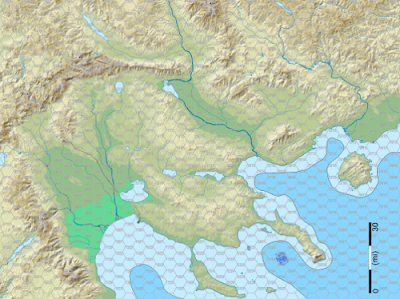
Read a blog post recently (sorry lost which one in the deluge). It noted that the map of Greece with all those islands and rugged terrain screams for adventure and begs to be explored. At the time I thought, "yeah, meh, whatever". Later when looking over my National Geographic map collection I noticed the Macedonia region on a relief map of the world. It was structurally close to what I had envisioned for GnG's map. And I began to grasp the wisdom of that blogger. After seeing the topo SVG map from that wiki page I knew I had found my cartographic grail.

It took some work to make the hex grid, and to scale the image so 1 hex = 5mi, and to make the several layers. I've also been adding swamps, raising mtns, and sinking a peninsula. Must watch myself though. Computer and detailedness makes it easy to fall into the over/endless editing trap. Must remember "broad brush strokes" and "detail it when you need it, not before" aka JIT. So far I'm happy and enjoying myself! No claims to be the best map ever. Works for me and more importantly has gotten my ass motivated to get this campaign started.

I present the Eastern Frontier. The safe, boring Kingdom lies off to the lower left. The rest is the unexplored!


I'm sort of sold (at least this week) on vector based / free hand maps and against the tyranny of the hexgrid. Which would seem to make Campaign Hexagon System compatibility a wee bit difficult. I resolve this by using hexgrid overlay on top of my nice hexfree map. Either via software "layers" or hexgrid printed on transparency. I create, draw, design without the grid, then throw the grid on for location write up / play. Hopefully getting best of both worlds. Here's the hexified version (sorry, only posted 1/4 sized images, but trust me those are numbered hexes)

A league is three miles and the distance man/horse can walk in an hour. I've decided to treat my 5mi hexes a 2 leagues or two hours of travel. Two hours seemed like a good duration for a wilderness "turn". Probably about the time travelers should rest and reorientate themselves. Also nice time to checks for encounters, getting lost, etc. A group can do 4 (5 if pushing it) turns of wilderness travel.


Reality Ain't So Bad

Since working on this I've discovered several advantages to using real word maps. First and most obvious is that you get a fairly detailed map with very little work. There's likely to be many more maps of various types depicting the area, for free online. Such as these awesome topo maps. At the very least there will be Google Map sat images and topo maps. I find it difficult to visualize terrain from a map, even topo maps. Google Earth provides a whole new perspective :). Google Earth is also great for finding photos taken of the area. These provide more visual aides, ideas for descriptions, flora, and fauna. One boon I wasn't expecting is that several times already the map had a feature that inspired me to add something to the game world I had not thought of.

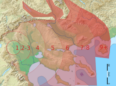
This version shows roughly the "bands" of increasing danger as you get farther away from the edge of civilization aka the "keep on the borderlands". Going further to the west (and off map) the bands would decrease until one reached the Stygian Empire. Up North is... something. It's good to keep a few mysteries.


Hexaphobia

Ars Lundi "Running your Own Western Marches" and my own tendency to be distracted by grid led to my avoidance of hexmaps. I still absolutely adore Mystara style maps. Which are the right thing for continental and world maps. At that scale you don't really care about the details cause you can't show enough of them to matter.

From Ars Lundi article:
It was a vector map, so I could zoom in or out to any scale I wanted. I printed a variety of maps at different scales if I there were interesting things to see in the area. No one needs a close-up map at one inch = one inch of a barren plain.

That author felt hexes lead to the belief/behavior of one thing per hex and once it's found players no longer interested in looking there. I can also see hexes removing the mystery and tension of exploring/getting lost, "meh, we're only 1 hex away from the road".

More from Ars Lundi:
I didn’t use hex maps, just free movement and distances. It kept things organic and made it easy to get lost / disoriented, which was good. To track movement I just got distances and bearings from the party (”we’ll march southwest for 2 miles”), checked to see if they were going the way they thought (wilderness lore) and then drew the vector on the map to see where they actually were.
YMMV


Blogbliography (incomplete as usual)

MkHexGrid

mkhexgrid software make almost any hexgrid you want, download it. A couple spec files I used:

#gng_letter_hex
output = ps
outfile = gng_letter_hex.ps
centered = true
image-width = 11in
image-height = 8.5in
image-margin = 0.3in
hex-width = 0.375in
grid-grain = h
grid-thickness = 0.5pt
grid-start = o
grid-color = 0.8,0.8,0.8
coord-origin = ur
coord-bearing = 0
coord-tilt = -90
coord-distance = 0.1in
coord-color = 0.6,0.6,0.6
center-style = n
coord-font = Helvetica
coord-size = 6pt

#jg_hexagon
output = ps
outfile = jg_hexagon.ps
centered = true
image-width = 11in
image-height = 8.5in
image-margin = 0.3in,0.3in,2in,0.3in
hex-width = 0.3in
grid-grain = h
grid-thickness = 0.5pt
grid-start = o
grid-color = 0.8,0.8,0.8
coord-origin = ur
coord-bearing = 0
coord-tilt = -90
coord-distance = 0.08in
coord-color = 0.6,0.6,0.6
center-style = n
coord-font = Helvetica
coord-size = 6pt

Wednesday, January 7, 2009

Links O' Maps

Oh giditty git, I loves me some maps. "Atlas" was my favorite book type as a kid. They were bigger than any other book in our house and smelled musty and old(from disuse my elder siblings weren't quit the nerd I am). The textures, the smells set my imagination leaping. Inside was filled with strange drawings, exotic names and fantasies yet to be dreamed. I was manifestly disappointed to find out the "Viking World Atlas" had nothing to do with axe wielding warriors in longships.

Antique maps are very awesome. Simply as works of art they kick ass. But it don't end there. This one of Iceland could be used straight up as a campaign map or player handout.

What's at the poles of your world? Perhaps this? The unknown lands far west across the endless sea. Black and white style map of Africa circa 1540.

Ancient map of Fairyland, a perspective drawing/map chock full of flavor. Perfect place for the other side of that magic mirror. That interface needs one more level of zoom though.

Hexmapper Haven cause old-school is the cool school. Oh, I so wish rpgmanager hexmapper program v2 would get completed/released. I offer up my first born, second born, all the fruits of my loins. Sorry, I'm keeping my dog.


Many tactical maps, more, similar that are gridded with 1" squares for use with miniatures.

These are also perfect for use with virtual desktop software for gaming online. Such as the most excellent MapTool.


Maps of Hyboria for all your savage barbaric needs.

Need a bit of terrain? Ever wonder what a map of the area you live would look like? Check out US Topo maps. I based my first campaign on topo maps of Norway.

Totally rad map of natural cave formations and the processes that form them. In fact it's so rad I'm embedding it below. Just one of the rockin results of searching the Google for Lechuguilla Cave Map. A huge cave complex that has been extensively mapped. You can buy a physical map of the similar Jewel Cave.


There's no more awesomer ending than that to this installment of the semi-thematic link blog series posted every Wednesday.

All Time Most Popular Posts